
Free and Open Source
QGIS Feed
Explore the latest updates, news, and resources for the QGIS community.
Explore the latest updates, news, and resources for the QGIS community.
You can also access the QGIS News Feed in JSON format.
QGIS turned 20 last year. Help us get ready for the next 20+ years by becoming a sustaining member!
Every contribution counts.
Double-click this news entry to find out more!
On Friday (27th January 2023) we will be holding our regular monthly QGIS Open Day event! QGIS Open Days promote dialogue and sharing of skills, knowledge and experience within the QGIS community. They are also a great way to sit back and have a little fun with other QGIS users from around the world!
We hope you will join us for the exciting sessions we have planned. Double-click this news entry to find out more! If you cannot join the live event, all sessions will be recorded and uploaded to the official QGIS YouTube channel.
On Friday (25th November 2022) we will be holding our regular monthly QGIS Open Day event! QGIS Open Days promote dialogue and sharing of skills, knowledge and experience within the QGIS community. They are also a great way to sit back and have a little fun with other QGIS users from around the world!
We hope you will join us for the exciting sessions we have planned. Double-click this news entry to find out more! If you cannot join the live event, all sessions will be recorded and uploaded to the official QGIS YouTube channel.

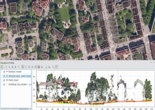
Would you like to help improve point clouds, elevation profiles and 3D map views in QGIS? Lutra Consulting, North Road and Hobu are collaborating in a new crowd-funding campaign to extend these capabilities in future QGIS releases!
Highlights of the planned improvements include:
Your financial support is vital to make these improvements possible! Double-click on this entry to read the full details of this exciting campaign and how you can contribute.
This Friday (28th October 2022) we will be holding our regular monthly QGIS Open Day event! QGIS Open Days promote dialogue and sharing of skills, knowledge and experience within the QGIS community. They are also a great way to sit back and have a little fun with other QGIS users from around the world!
We hope you will join us for the exciting sessions we have planned. Double-click this news entry to find out more! If you cannot join the live event, all sessions will be recorded and uploaded to the official QGIS YouTube channel.
QGIS will drop 32-bit support on Windows after the QGIS 3.16 release when we update our Qt dependencies to Qt 5.15. The update to Qt 5.15 is an important step towards staying in sync with Qt developments. Qt 5.15 is the minimum version that will provide forward compatibility with Qt 6. By updating to 5.15, we, therefore, ensure that QGIS is future proof. Please double-click this entry to find out more.
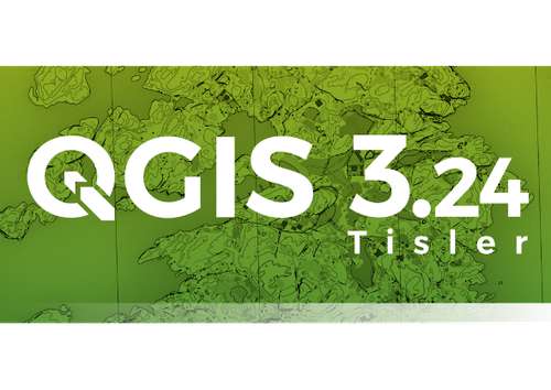
We are extremely proud to present QGIS 3.24 to you, our loyal users. This release is jam-packed with great new features, bug fixes and cartography tools. We named this release 'Tisler' after a small Norwegian island that was a favourite visiting place of Håvard Tveite, who passed away in May 2021. Håvard was a very active member of the QGIS community, providing valuable input to the documentation, developing numerous plugins, and taking care of the QGIS Resources Sharing Repository to name just a few of his contributions. The map on the QGIS 3.24 splash screen is an orienteering map that Håvard has created. He liked spending some time each year map-making at Tisler. To find out more about the wonderful features included in QGIS 3.24, please double click this entry.
Have you been missing all the buzz and excitement around the 6-monthly in-person meetups we used to hold? Perhaps you live far away from Europe and could never join these meetups in person? Well we have great news for you! Starting August Friday 28th 2020, we will be holding day-long virtual meetups on the last friday of each month. Come and chat to the developers and maintainers of QGIS and it's related infrastructure. Talk to other users to share tips and tricks. Collaborate with other like-minded users to work on inititives for yourselves and your community. Attendance is free and all are welcome regardless of your experience or past involvment in the project. Double-click on this news feed entry to find out more!
Dear QGIS community, we recently completed the 2020 PSC election process whereby the community votes for their favourite community members to help steer the future of QGIS. I am really honoured and excited to have been entrusted with the task of representing our fantastic community and I am really happy to have such an amazing PSC helping me in taking QGIS to even greater heights. To find out more about the outcome of the QGIS PSC elections, the AGM and my vision, double-click this message to open it in your browser.
Do you want to see all the fantastic new features and bug fixes that were introduced in QGIS 3.14? Double-click this message to open the visual changelog in your browser. Our visual changelogs provide a nice, centralized list of all the key new features in each release. Each feature description is usually accompanied by an image or short screen recording. We extend our grateful acknowledgment to our many sustaining members, donors, volunteers and developers who made this release a reality.

Flagship membership

Flagship membership

Flagship membership

Large membership

Large membership

Large membership

Large membership

Large membership

Large membership

Large membership

Large membership

Large membership


